Index of All Cemeteries Alphabetical Index of All Burials Previous Page
Use the following to search across all the cemeteries listed.
Example: "Smith, Roger" (yes, use the quotes)
611 UNKNOWN Possibly Enslaved Foushee or Burnette [D68.1]
Location: Baldwin Township. North side of Hamlet's Chapel Road, about 0.4 miles east of Moore Mountain Rd.
Coordinates: 35d 48m 01.3s N; 79d 08m 37.3s W Click here for Online Maps
4Additional cemetery photos:
View #2 of the cemetery. View #3 of the cemetery. View #4 of the cemetery.
View #5 of the cemetery. View #6 of the cemetery. View #7 of the cemetery.
Field survey and NC Cemetery Site Form..
Owner: Coffey Grounds of Chapel Hill, Inc., 127 Araya Lane, Chapel Hill, NC 26516. Previously Dan F. and Walter F. Harris.
Legal Description: Parcel 1795. Deed 1166/974.. See chain of title in attached report.
Topo Quadrant: Baldwin: D.
Family owned: Yes.
Abandoned: Yes.
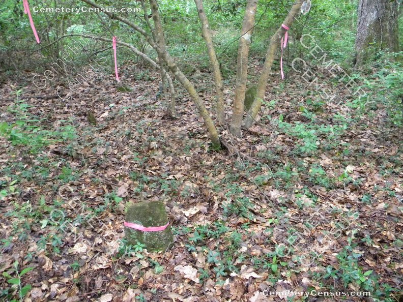
Condition: Overgrown, not easily identifiable.
Number of graves: 27 with other unmarked graves assumed.
Cemetery size: 0.12 acre.
Type: Probably enslaved (see attached report).
Restricted access: Yes, private property.
Enclosed: No.
Markers present: Yes.
Inscribed markers: No.
Number readable markers: 0.
Last burial: UNK.
First burial: UNK.
Unusual stones: No.
Markers damaged: No.
Hazards to cemetery: Property to be developed. Cemetery will require protection.
Listed: No.
Miscellaneous information: Developer John Coffey and Susie Shachtman showed Jim and Bev Wiggins to the site on 6 May 2021. The site was overgrown and periwinkle covered a large area. Several graves marked with fieldstones and other sunken areas were evident. Professional documentation of the cemetery was recommended and was completed by New South Associates on 21 Jun 2021. Coordinates and cemetery size, as well as number of graves are from that report. See report for complete details of the field survey and research suggesting that the cemetery is likely that of persons enslaved by the Foushee or Burnette families.
Last canvassed by: Bev Wiggins, Date: 07 June 2021; Sarah Lowry, New South Associates, 21 June 2021.
Web page updated 31 March 2023
Index of All Cemeteries Alphabetical Index of All Burials Previous Page
|
|
 |
