Index of All Cemeteries Alphabetical Index of All Burials Previous Page
Use the following to search across all the cemeteries listed.
Example: "Smith, Roger" (yes, use the quotes)
614 COLE REINTERMENT SITE [E23.2]
Location - Williams Township. Located in the woods behind the property at 185 Lystra Hills Lane, however, the cemetery is not accessible from that property. Access needs to be granted to
cross private property off of hwy 15-501, then a hike into the woods.
Coordinates: 35d 50m 15.8s N; 79d 04m 51.7s W Click here for Online Maps
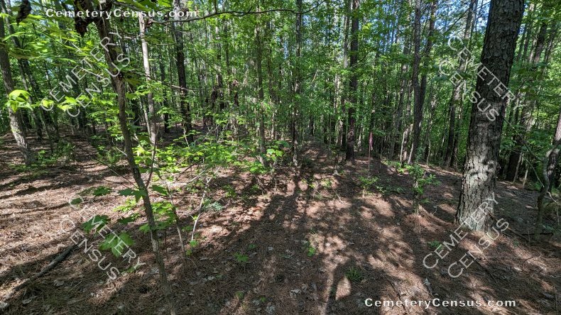
Additional cemetery photos:
View #2 of the cemetery. View #3 of the cemetery. View #4 of the cemetery.
View #5 of the cemetery. View #6 of the cemetery. View #7 of the cemetery.
View #8 of the cemetery. View #9 of the cemetery. View #10 of the cemetery. View #11 of the cemetery.
This cemetery [E23.2] is the reinterment site for the Cole cemetery, E22.2. In 2003, 38 graves were removed from the cemetery and reinterred on parcel 18892. [The reinterment location was inaccurately described and mapped in landscape plans referred to in the Environmental ImpactAssessment carried out in 2020. The field-verified location is reported here.] In 2023, four trenches were found. Details of the disinterment, a history of the property ownership, and list of some possible burials are included in an Environmental Impact Assessment carried out in
January of 2020. See the relevant section of that report here E23.2-removal-to-new-location.
See E22.2 for more information about the original cemetery.
Owner: 501 PRAIRIE VIEW LLC Formerly: Thomas A. Bland, Jr., and Patricia S. Bland. See above referenced report for more detail.
Legal Description: Parcel 18892. Deed 2327/0660. Plat 2022-0019. Cemetery is shown on the plat.
Topo Quadrant: Farrington.
Abandoned: Yes.
Number of graves: 38.
Cemetery size: 0.139 acre.
White: Yes.
Restricted access: Yes. Private property.
Not easily identifiable as a cemetery.
Not identified explanation: Reinterment was in four trenches, each approximately 21-23 feet in length. The burials were marked only by temporary flagging at the time of the field visit in 2023.
Enclosed: No.
Markers: No markers were observed in 2023 site visit.
Markers with inscriptions: No.
Canvassed by: Will M. Heiser. Date: 4 Jan 1997; Wetlands and Waters firm EIA, Jan 2020. In April 2023, CCHA volunteer Kelly Gomez was accompanied by Chris Ehrenfield of Bold Land Development to the reinterment site for E22.2. Access to the site is deep into the woods and had to be hiked into. Four trenches have been dug, each approximately 21-23 feet in length, where burials were relocated. Each of these four trenches had been marked on one of its ends by pink survey tape, wrapped around a tree.
Web page updated 8 May 2023
Index of All Cemeteries Alphabetical Index of All Burials Previous Page
|
|
 |
