Index of All Cemeteries Alphabetical Index of All Burials Previous Page
Use the following to search across all the cemeteries listed.
Example: "Smith, Roger" (yes, use the quotes)
349 SHACKELFORD, WILLIAM CEMETERY
Location - Off Chilton Rd at Deer Pond Lane, Ararat, Surry Co., NC.
Coordinates: 36d 23m 07.2s N; 80d 33m 33.4s W Click here for Online Maps
Directions: From the intersection of NC Hwy 268 and Eldora Rd (SR 2038), go north on Eldora Rd for 3.3 miles and turn right on Chilton Rd (SR 2043). Then go abt 0.7 mile and turn right at Deer Pond Lane and pull over to the road edge. On the left side of Deer Pond Lane is a small area of woods and the graves are located about midway in the trees.
Surveyed by John Edwards on February 7, 2007.
Township or district: Siloam.
Public or Private: Private property.
GPS Accuracy (ft.): 23.
Elevation above sea level (ft.): 1121.
Status of cemetery: Abandoned.
Burial survey recorded by Bob Carter of Greensboro, NC on 30 Oct 2014.
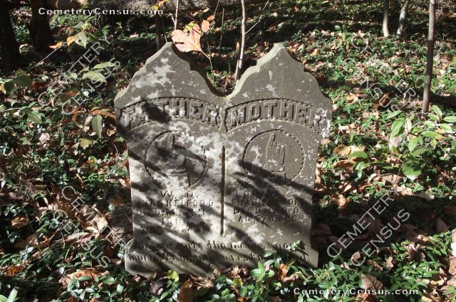
The cemetery name was initially shown by John Edwards as the Ashburn Family Cemetery, but there were no visible markers or historical evidence for Ashburn family members. The only graves found were that of William O. Shackelford and his wife Louisa "Luisey" W. Pringle. There is a large pile of field stones, some of which could have been burial markers although some of them are clearly too large to have been for graves.
 Shackelford, Louisa W. Pringle "Luisey" (b. Abt 1824 - d. 7 Mar 1890) Shackelford, Louisa W. Pringle "Luisey" (b. Abt 1824 - d. 7 Mar 1890) Wife of William O. Shackelford. Age 78 yrs. Born in VA and died in Surry County.
- Shackelford, William O. (b. Abt 1818 - d. 7 Mar 1890)
Husband of Luisey W. Pringle, m. 26 Feb 1854 in Stokes County, NC. Age 72 yrs. Born in Stokes County, NC and died in Surry County.
- Unknown, Unknown (b. Unknown - d. Unknown)
Stones piled up, some of which could have been markers.
Web page updated 15 April 2021
Index of All Cemeteries Alphabetical Index of All Burials Previous Page
|
|
 |